
![]()
tigris is an R package that allows users to directly download and use TIGER/Line shapefiles (https://www.census.gov/geographies/mapping-files/time-series/geo/tiger-line-file.html) from the US Census Bureau.
To install the package from CRAN, issue the following command in R:
install.packages('tigris')Or, get the development version from GitHub:
devtools::install_github('walkerke/tigris')tigris functions return simple features objects with a default year of 2024. To get started, choose a function from the table below and use it with a state and/or county if required. You’ll get back an sf object for use in your mapping and spatial analysis projects:
library(tigris)
library(ggplot2)

manhattan_roads <- roads("NY", "New York")

ggplot(manhattan_roads) +
  geom_sf() +
  theme_void()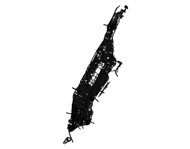
tigris only returns feature geometries for US Census data which default to the coordinate reference system NAD 1983 (EPSG: 4269). For US Census demographic data (optionally pre-joined to tigris geometries), try the tidycensus package. For help deciding on an appropriate coordinate reference system for your project, take a look at the crsuggest package.
To learn more about how to use tigris, read Chapter 5 of the book Analyzing US Census Data: Methods, Maps, and Models in R.
Python users may also be interested in pygris, a Python port of the tigris package.
Available datasets:
Please note: cartographic boundary files in tigris are not available for 2011 and 2012.
| Function | Datasets available | Years available |
|---|---|---|
nation() |
cartographic (1:5m; 1:20m) | 2013-2024 |
divisions() |
cartographic (1:500k; 1:5m; 1:20m) | 2013-2024 |
regions() |
cartographic (1:500k; 1:5m; 1:20m) | 2013-2024 |
states() |
TIGER/Line; cartographic (1:500k; 1:5m; 1:20m) | 1990, 2000, 2010-2024 |
counties() |
TIGER/Line; cartographic (1:500k; 1:5m; 1:20m) | 1990, 2000, 2010-2024 |
tracts() |
TIGER/Line; cartographic (1:500k) | 1990, 2000, 2010-2024 |
block_groups() |
TIGER/Line; cartographic (1:500k) | 1990, 2000, 2010-2024 |
blocks() |
TIGER/Line | 2000, 2010-2024 |
places() |
TIGER/Line; cartographic (1:500k) | 2011-2024 |
pumas() |
TIGER/Line; cartographic (1:500k) | 2012-2024 |
school_districts() |
TIGER/Line; cartographic | 2011-2024 |
zctas() |
TIGER/Line; cartographic (1:500k) | 2000, 2010, 2012-2024 |
congressional_districts() |
TIGER/Line; cartographic (1:500k; 1:5m; 1:20m) | 2011-2024 |
state_legislative_districts() |
TIGER/Line; cartographic (1:500k) | 2011-2024 |
voting_districts() |
TIGER/Line | 2012, 2020 |
area_water() |
TIGER/Line | 2011-2024 |
linear_water() |
TIGER/Line | 2011-2024 |
coastline |
TIGER/Line() | 2013-2024 |
core_based_statistical_areas() |
TIGER/Line; cartographic (1:500k; 1:5m; 1:20m) | 2011-2021, 2023-2024 (not available for 2022) |
combined_statistical_areas() |
TIGER/Line; cartographic (1:500k; 1:5m; 1:20m) | 2011-2024 |
metro_divisions() |
TIGER/Line | 2011-2024 |
new_england() |
TIGER/Line; cartographic (1:500k) | 2011-2021 (no longer used by Census) |
county_subdivisions() |
TIGER/Line; cartographic (1:500k) | 2010-2024 |
urban_areas() |
TIGER/Line; cartographic (1:500k) | 2012-2024 |
primary_roads() |
TIGER/Line | 2011-2024 |
primary_secondary_roads() |
TIGER/Line | 2011-2024 |
roads() |
TIGER/Line | 2011-2024 |
rails() |
TIGER/Line | 2011-2024 |
native_areas() |
TIGER/Line; cartographic (1:500k) | 2011-2024 |
alaska_native_regional_corporations() |
TIGER/Line; cartographic (1:500k) | 2011-2024 |
tribal_block_groups() |
TIGER/Line | 2011-2024 |
tribal_census_tracts() |
TIGER/Line | 2011-2024 |
tribal_subdivisions_national() |
TIGER/Line | 2011-2024 |
landmarks() |
TIGER/Line | 2011-2024 |
military() |
TIGER/Line | 2011-2024 |